Surveying and site investigationSurveying
Capturing the needs of the times
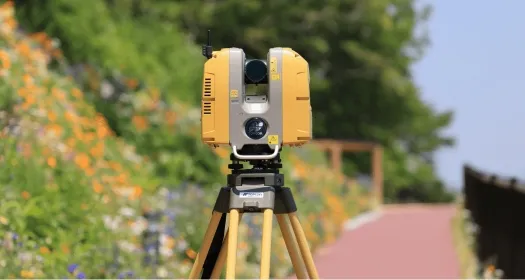
Providing cutting-edge surveying technology
In addition to traditional public surveys, we also carry out surveying work that corresponds to the i-Construction promoted by the Ministry of Land, Infrastructure, Transport and Tourism. In addition, when land acquisition occurs, we respond to customer needs by conducting land boundary surveys and surveys, and investigating and calculating compensation properties.
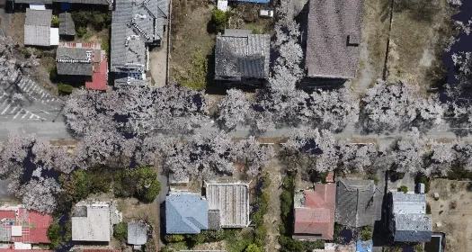
・Reference point surveying/leveling Topographical survey and photogrammetry
・On-site surveying ・Vehicle-mounted photo laser surveying ・UAV photo point cloud surveying ・Terrestrial laser surveying ・UAV laser surveying ・UAV green laser surveying ・Construction surveying ・Completion management ●Applied Surveying
・Route surveying, river surveying, bathymetric surveying, land surveying
Please watch the video for details
Representative work and resultsTypical business / results
-
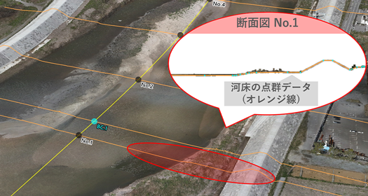
River channel survey using UAV green laser
UAV green laser surveying can be used for river improvement planning, surveying associated with river channel excavation, and calculating uneven flow. It enables more detailed surveys and can also be used to calculate the amount of sediment and scouring for the planned cross section, as well as to understand the current situation and consider restoration methods in the event of a disaster.
-
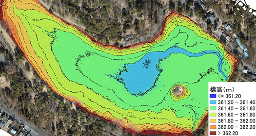
Survey of sediment runoff volume using UAV green laser
By measuring the riverbed topography of lakes and ponds at two different times using a UAV green laser, it is possible to grasp the amount of sediment runoff, which can be used to plan maintenance such as dredging. In addition, by conducting bottom sediment surveys, it is possible to propose issues and investigation methods to concretize future maintenance plans.
-
Analysis of revetment settlement
By regularly monitoring coastal protection facilities using UAV green laser surveying, it is possible to grasp the amount of changes, etc., and use this information for appropriate maintenance and management to prevent and mitigate disasters.
-
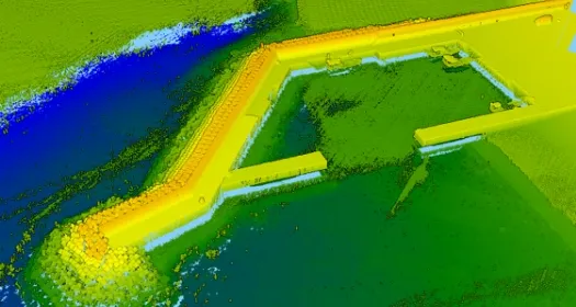
Maintenance of levees and revetments
By regularly monitoring port and fishing port conservation facilities through UAV surveying, it is possible to understand changes over time and the impact of natural disasters, and use this information for appropriate maintenance and management to reduce and prevent disasters.
-
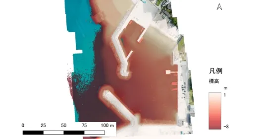
Survey of buried waterways
UAV green laser surveying measures the topography of the port and helps understand the status of channels being silted up by sediment to ensure safe ship operation. This can be used for appropriate maintenance and management to prevent and mitigate disasters.
-
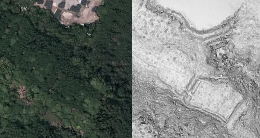
Surveying ruins under the forest
We use UAVs to take photographs and perform laser scanning. Laser scanning allows for topographical surveying within forests, and we create maps using UAV photographs and point clouds. We also create videos from point cloud data.
-

Preservation surveys of ruins and cultural properties
Terrestrial lasers are used to record and measure cultural assets such as historical buildings and stone walls. Point cloud data can be used to create various drawings such as cross-sections and videos, and can also be used for restoration.
-

Disaster survey using UAVs
By using UAVs to take aerial photographs of open areas such as rivers, farmland, and coastlines, it is possible to identify widespread damage, identify dangerous areas that are difficult to access, and grasp the scale of the damage. In the 2024 Noto Peninsula earthquake, we responded to the disaster as part of Tec-Force (Emergency Disaster Response Team).
-
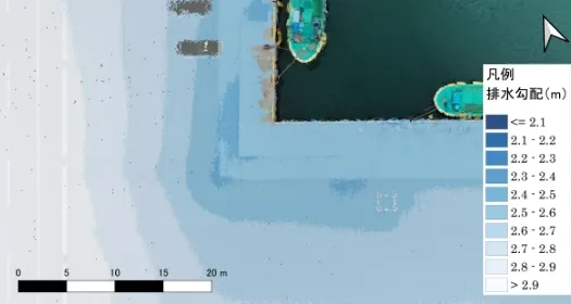
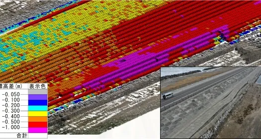
Checking subsidence/uplift conditions and drainage gradients
Using various 3D surveying technologies, it is possible to obtain height information over a wide area and compare it with existing height information to grasp the amount of change. By using contour lines and color-coding to display the height, it is possible to easily check the amount of settlement and drainage gradient.
-
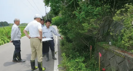
Land boundary survey, compensation property survey
We investigate and measure the boundaries of land necessary for civil engineering work, and if there are any compensation properties, we also investigate and calculate them.
-
Earth volume calculation/finished form management
We calculate the volume of soil from 3D point clouds. By measuring data before and after construction, we can perform highly accurate calculations and manage the completed form.
-
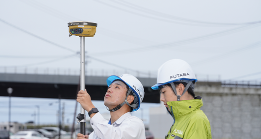
GNSS surveying
Control point surveying and leveling, which are the foundation of surveying, are carried out using multi-GNSS surveying.
-
UAV photogrammetry
We take aerial photographs using unmanned aerial vehicles (UAVs) and create photographic maps (orthoimages) and 3D point cloud data.
-
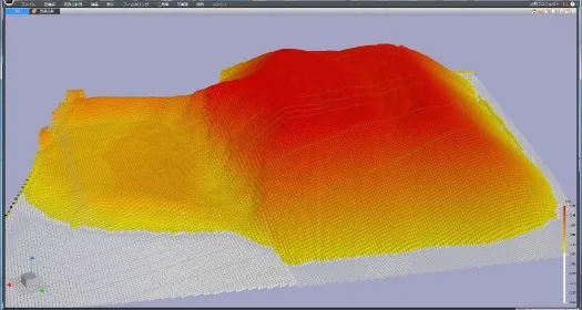
3D laser measurement
Measurements are taken using a 3D laser scanner to create 3D point cloud data of reclaimed land, roads, buildings, etc.
List of work and resultsList of operations and results
| year | Client | Business content |
|---|---|---|
| R04 | City/town/village | Route survey and design outsourcing |
| R04 | City/town/village | Drainage survey and design work outsourcing |
| R04 | City/town/village | Outsourcing of 3D laser surveying of stone walls and topography within the castle ruins |
| R04 | Fukushima Prefecture | Comprehensive reconstruction infrastructure development 0304 project |
| R04 | City/town/village | Outsourcing of detailed design work for disaster recovery of agricultural land, etc. |
| R04 | Fukushima Prefecture | Road disaster restoration survey and design work outsourcing |
| R04 | Fukushima Prefecture | Comprehensive Reconstruction Infrastructure Development Project Southern District Control Point Survey |
| R03 | Fukushima Prefecture | Surveying and design work outsourcing (fishing port disaster investigation) |
| R03 | Fukushima Prefecture | Surveying work outsourcing (erosion control facilities) |
| R03 | Fukushima Prefecture | Fukushima Survey 0204 Business Survey |
| R03 | Fukushima Prefecture | Disaster prevention forest creation (reconstruction and revitalization) 0101 work |
| R03 | Fukushima Prefecture | Comprehensive reconstruction infrastructure development project Observation control point survey work |
| R03 | City/town/village | Water facility repair work surveying and design work outsourcing |
| R03 | City/town/village | Hydrographic survey design commission |
| R03 | City/town/village | Industrial park confirmation surveying work outsourcing |
| R02 | Fukushima Prefecture | Survey design work outsourcing (road preparation/restoration) |
| R02 | Fukushima Prefecture | Surveying work outsourcing (erosion control facilities) |
| R02 | Fukushima Prefecture | Disaster prevention forest creation (reconstruction and revitalization) 0101 work |
| R02 | Fukushima Prefecture | Surveying and design work outsourcing (urban parks and memorials) |
| R02 | City/town/village | Forest Comprehensive Development Project Survey and Design Outsourcing |
| R02 | City/town/village | Reconstruction base surveying work outsourcing (part 2) |
| R02 | City/town/village | Hydrographic survey design work outsourcing |
| R02 | City/town/village | Slope restoration survey and design outsourcing |
| R02 | Wide area | Site preparation design commission |
| H31 | Fukushima Prefecture | Agriculture, Forestry and Fisheries 0101 Business Design |
| H31 | Fukushima Prefecture | Comprehensive reconstruction development 0102 business |
| H31 | Fukushima Prefecture | Comprehensive reconstruction infrastructure development for mountainous areas 0102 project |
| H31 | Wide area | Comprehensive reconstruction infrastructure development project: Control point survey work |
| H31 | City/town/village | Survey and design work for District Road Route 60 |
| H31 | City/town/village | Infrastructure survey and design outsourcing |
| H31 | City/town/village | Comprehensive forestry survey and investigation work |
| H30 | Fukushima Prefecture | Dam leakage investigation work |
| H30 | Fukushima Prefecture | Land surveying for the Reconstruction Memorial Park |
| H30 | Fukushima Prefecture | Fishing port land surveying service |
| H30 | Fukushima Prefecture | Disaster prevention forest non-legal public property survey work |
| H30 | Fukushima Prefecture | Fishing port land surveying service |
| H30 | Fukushima Prefecture | Disaster prevention forest land surveying work |
| H30 | Fukushima Prefecture | Disaster prevention forest non-legal public property survey work |
| H30 | City/town/village | Land surveying for reconstruction bases |
| H30 | City/town/village | Dam sediment survey work |
| H30 | City/town/village | Public land surveying work |
| H30 | private company | Preliminary surveys and consent acquisition work related to decontamination |
| H30 | private company | Agricultural waterway surveying work |
| H30 | subcontractor | Reservoir surveying work |