Surveying and site investigationSurveying
時代のニーズを捉え
一歩先の測量技術を提供
従来の公共測量はもとより、国土交通省が推進するi-Constructionにも対応した測量業務を実施します。また、用地の取得などが発生した場合、土地の境界調査や測量、補償物件の調査や算定など、お客様のニーズに応えます。
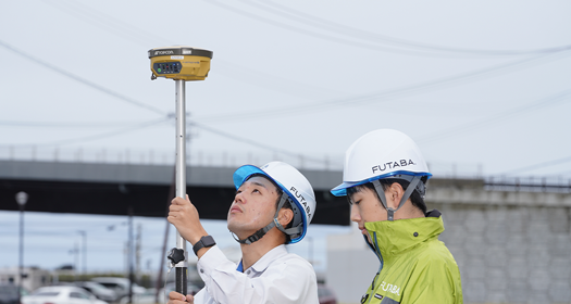
・基準点測量・水準測量 Topographical survey and photogrammetry
・現地測量・車載写真レーザ測量・UAV写真点群測量・地上レーザ測量・UAVレーザ測量・UAVグリーンレーザ測量・起工測量・出来高管理 ●Applied Surveying
・路線測量・河川測量・深浅測量・用地測量
詳しくは動画をご覧ください
代表的な業務・成果例Typical business / results
-
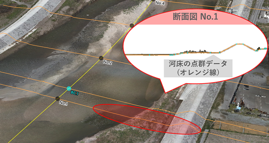
UAVグリーンレーザによる河道調査
UAVグリーンレーザ測量は、河川の整備計画・河道掘削に伴う測量及び不等流計算等に活用できます。より詳細な調査が可能になるとともに、計画断面に対する堆砂及び洗堀量の算出や災害発生時の現況把握及び復旧工法の検討などにも活用できます。
-
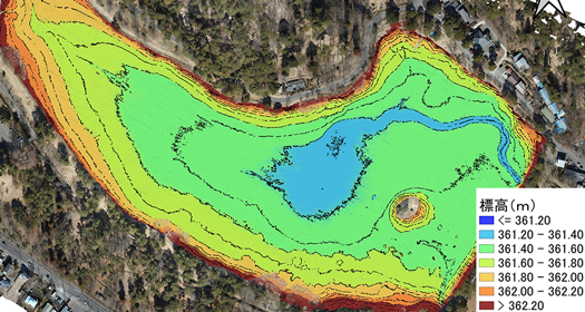
UAVグリーンレーザによる土砂流出量調査
UAVグリーンレーザを用いて、湖沼の二時期の河床地形を計測することで、土砂の流出量を把握でき、浚渫等の維持管理計画に役立てることが可能です。また、底質調査等の実施により、今後の維持管理計画の具体化に向けた課題と調査方法を提案できます。
-
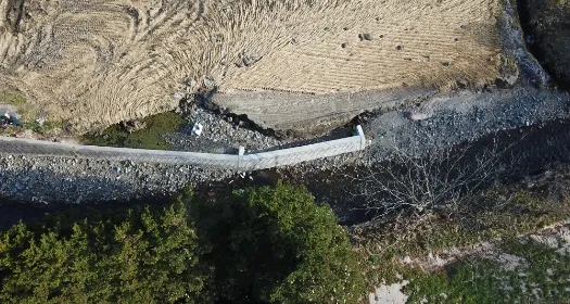
護岸の沈下解析
UAVグリーンレーザ測量により、海岸保全施設を定期的にモニタリングすることで、変化量などを把握し、防災・減災のための適切な維持管理に活用できます。
-
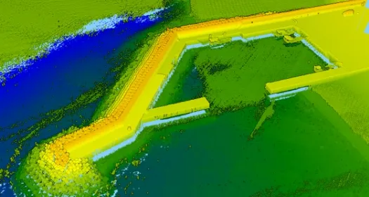
堤防・護岸の維持管理
UAVによる測量による、港湾・漁港保全施設を定期的にモニタリングすることにより、経年変化や自然災害による影響などを把握し減災・防災のための適切な維持管理に活用できます。
-
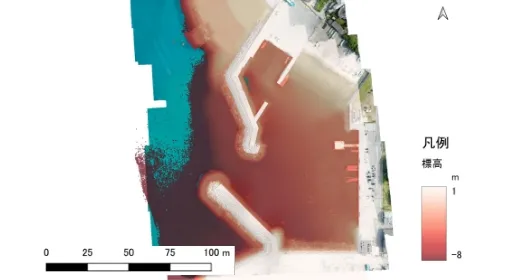
航路埋没調査
UAVグリーンレーザ測量により港内の地形を計測し、船の安全な運行のため堆砂による航路埋没の状況などを把握することで、防災・減災のための適切な維持管理に活用できます。
-
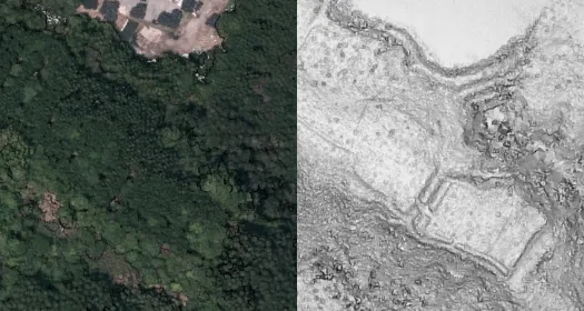
森林下の遺跡調査
UAVを用いた写真撮影やレーザスキャニングを行います。レーザスキャニングでは森林内の地形測量が可能で、UAV写真や点群を用いて図面の作成を行います。点群データから動画の作成も行います。
-
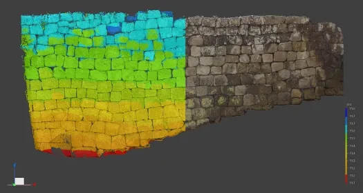
遺跡・文化財の計測・記録
歴史的建造物や石垣等の文化財には地上レーザを用いた記録・計測を行います。点群データより断面図等の各種図面や動画の作成が可能で、さらには復元にも活用することができます。
-
UAVによる災害調査
上空が開けている河川や農地などに対してUAVにより空撮することで、広範囲の被災現場や接近が危険な現場の災害箇所の特定その規模などを把握することが可能です。
-
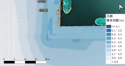
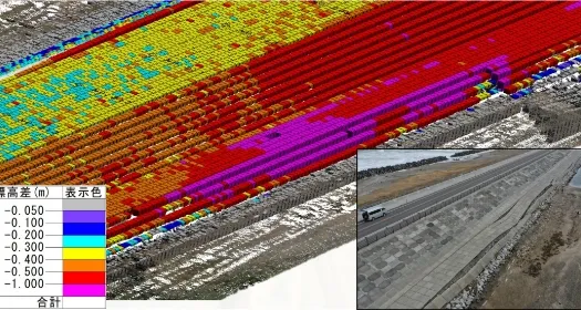
沈下・隆起状況や排水勾配の確認
各種三次元測量技術により、広範囲の高さ情報を取得し既存の高さ情報と比較することで変化量を把握可能です。等高線や色分けなどの表示を工夫することで沈下量や排水勾配をわかりやすく確認できます。
-
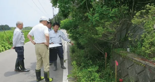
土地の境界測量、補償物件調査
土木施工に必要な土地の境界の調査や測量をし、補償物件などがある場合はその調査や算定を行います。
-
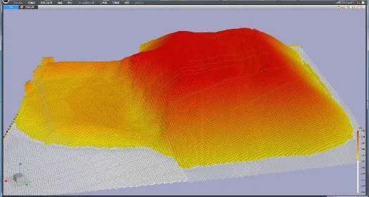
土量計算・出来形管理
三次元点群から土量を算出致します。施工前後のデータを計測することにより高精度な算出や出来形管理を行います。
-
GNSS測量
測量の根幹となる基準点測量や水準測量をマルチGNSS測量により行います。
-
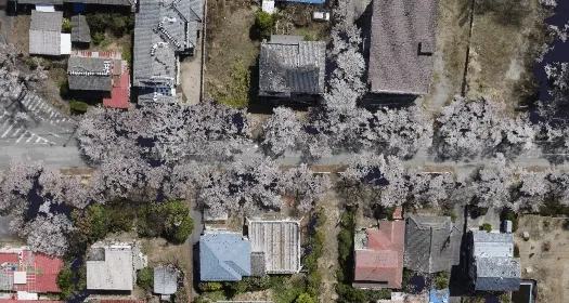
UAVによる写真測量
無人航空機(UAV)による空撮を行い、写真図(オルソ画像)や三次元点群データを作成します。
-
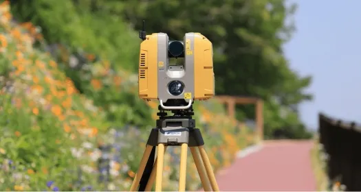
3Dレーザ計測
3Dレーザスキャナによる計測を行い、造成地、道路、建物等の三次元点群データを作成します。
業務・成果一覧List of operations and results
| 年度 | 発注者 | 事業内容 |
|---|---|---|
| R04 | 市町村 | 路線測量調査設計業務委託 |
| R04 | 市町村 | 排水路測量調査設計業務委託 |
| R04 | 市町村 | 城跡内石垣及び地形三次元レーザ測量業務委託 |
| R04 | 福島県 | 復興基盤総合整備0304業務 |
| R04 | 市町村 | 農用地等災害復旧実施設計業務委託 |
| R04 | 福島県 | 道路災害復旧測量設計業務委託 |
| R04 | 福島県 | 復興基盤総合整備事業 南部地区 確測基準点測量業務 |
| R03 | 福島県 | 測量設計業務委託(漁港災害調査) |
| R03 | 福島県 | 測量業務委託(砂防施設) |
| R03 | 福島県 | 福島調査0204業務測量 |
| R03 | 福島県 | 防災林造成(復興創生)0101業務 |
| R03 | 福島県 | 復興基盤総合整備事業 観測基準点測量業務 |
| R03 | 市町村 | 水利施設補修工事測量設計業務委託 |
| R03 | 市町村 | 水路測量設計委託 |
| R03 | 市町村 | 産業団地確定測量業務委託 |
| R02 | 福島県 | 測量設計業務委託(道整・再復) |
| R02 | 福島県 | 測量業務委託(砂防施設) |
| R02 | 福島県 | 防災林造成(復興創生)0101業務 |
| R02 | 福島県 | 測量設計業務委託(都市公園・祈念) |
| R02 | 市町村 | 林総合整備事業測量設計業務委託 |
| R02 | 市町村 | 復興拠点測量業務委託(その2) |
| R02 | 市町村 | 水路測量設計業務委託 |
| R02 | 市町村 | 法面復旧測量設計業務委託 |
| R02 | 地域広域 | 敷地造成設計委託 |
| H31 | 福島県 | 農林水産0101業務設計 |
| H31 | 福島県 | 復興総合整備0102業務 |
| H31 | 福島県 | 復興基盤総合整備中山間0102業務 |
| H31 | 地域広域 | 復興基盤総合整備事業 確測基準点測量業務 |
| H31 | 市町村 | 区画道路60号線測量設計業務 |
| H31 | 市町村 | 基盤整備測量設計業務委託 |
| H31 | 市町村 | 山林総合整備測量調査業務 |
| H30 | 福島県 | ダム漏水調査業務 |
| H30 | 福島県 | 復興祈念公園用地測量業務 |
| H30 | 福島県 | 漁港用地測量業務 |
| H30 | 福島県 | 防災林法定外公共物調査業務 |
| H30 | 福島県 | 漁港用地測量業務 |
| H30 | 福島県 | 防災林用地測量業務 |
| H30 | 福島県 | 防災林法定外公共物調査業務 |
| H30 | 市町村 | 復興拠点用地測量業務 |
| H30 | 市町村 | ダム堆砂測量調査業務 |
| H30 | 市町村 | 公共用地測量業務 |
| H30 | 民間企業 | 除染に係る事前調査及び同意取得業務 |
| H30 | 民間企業 | 農業用水路測量業務 |
| H30 | 下請け | ため池測量業務 |