Construction ConsultingConstruction consulting
Leveraging the strengths of local companies
Contributing to solving local issues
●General civil engineering (roads, etc.) ●Agricultural civil engineering ●Water supply and sewerage ●Rivers and coasts ●Fishing ports ●Regional design (urban development)
General civil engineering (roads, etc.)Civil engineering in general (roads, etc.)
Infrastructure such as roads, bridges, parks, and industrial parks is important social capital that supports the foundations of local industry and life, and is an essential facility for local people to live safely, securely, and comfortably.We provide consulting services related to various infrastructure developments (mainly roads, water supply and sewerage systems, industrial parks, etc.), from surveys, analysis, planning, design, to maintenance and management.
Please watch the video for details
agricultural civil engineeringAgricultural engineering
With Japan's food self-sufficiency rate stagnating compared to other developed countries, improving the country's self-sufficiency rate is a major challenge. To achieve this, it is necessary to expand farmland, improve the development of agricultural irrigation channels, and increase work efficiency. We provide consulting services related to the surveying and design of various agricultural infrastructure facilities, such as field improvement (plotting of rice paddies and fields), farm roads, irrigation channels, drainage channels, and headworks.
Please watch the video for details
Water/sewerageWater and sewage
Water supply and sewerage systems are essential social capital for our comfortable and healthy lives. They are also important infrastructure related to preserving the water quality of the water environment that surrounds us. We provide consulting services that cover everything from surveys and analysis to planning, design, and maintenance, taking into consideration the functions and regional characteristics of water supply and sewerage systems.
Please watch the video for details
Rivers and coastsRivers / Coasts
Rivers and coasts are important social capital that protect the lives and property of the people and preserve the local natural environment.To create safe, secure, and comfortable communities, we provide consulting services that cover everything from surveys and analysis to planning, design, and maintenance, taking into consideration the local landscape, usage characteristics, and ecosystems, such as the construction of river and coastal embankments and various structures, as well as the development of walking and relaxation areas.
Please watch the video for details
fishing portFishing port
Fishing ports are important social capital that is essential for the stable supply of seafood.
In order to protect the safety and security of people's lives, promote local industries, and create a lively community, we provide consulting services ranging from surveys, analysis, planning, design, and maintenance of fishing port facilities such as breakwaters, quays, waterways, and anchorages.
Please watch the video for details
Regional Design (Urban Development)Town planning
In order to contribute to the creation of safe, secure and comfortable towns, we carry out legal urban planning and urban policies such as land use, as well as urban and regional design and development, and also support resident-led town development activities such as social experiments and demonstration projects.In particular, as a local consulting company, our mission is to support new town development by formulating community development plans for recovery and reconstruction from the Great East Japan Earthquake and nuclear accident, and supporting workshops led by local residents, while utilizing new technologies such as VR.
Please watch the video for details
Representative work and resultsTypical business / results
-
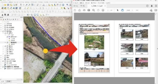
UAV-based longevity plan
UAV photography allows for efficient surveys. By combining a bird's-eye view with visual inspection, it is possible to create easy-to-understand reports. In addition, by centrally managing survey results using GIS, it is possible to use them for register maintenance.
-
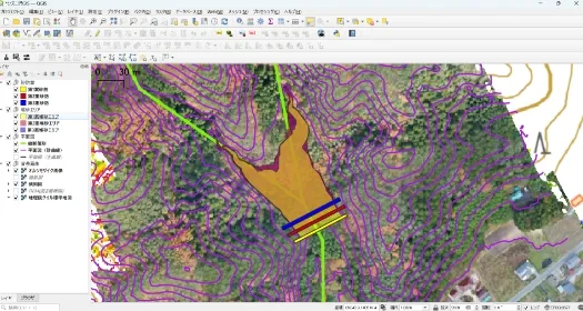
Examination of sabo dam locations using UAVs
We use UAV laser surveying to carry out topographical surveys under forests. Using the acquired point cloud data, we create shaded relief maps and slope maps to determine topographical conditions and consider dam locations. The created data is centrally managed in GIS, allowing us to quickly provide the necessary information.
-
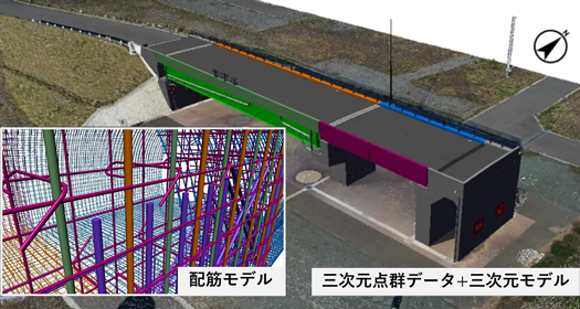
CIM
You can create 3D models with a detail level of 100 to 400 and use them for maintenance and management. At a detail level of 400, you can express a reinforcement model of the structure, and by combining it with 3D point cloud data, you can increase reproducibility. This allows for a fundamental reform in productivity improvement.
-
Driving simulation
By creating a 3D model, we can perform driving simulations. By combining it with point cloud data measured by UAVs, etc., we can check visibility while driving and convey future images in an easy-to-understand manner.
-
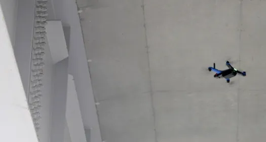
Bridge inspection using UAVs
By utilizing a highly maneuverable UAV, we can conduct efficient surveys. The six cameras mounted on the aircraft detect and automatically avoid obstacles in all directions, making it possible to survey and photograph even narrow areas such as between T-girders.
-
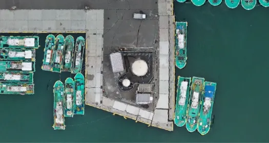
Maintenance and management of fishing port facilities
By using UAVs to regularly monitor fishing port structures, quays, and other facilities, it is possible to understand changes over time and the extent of damage caused by natural disasters, and use this information for appropriate maintenance and management to reduce and prevent disasters.
-
Park Planning and Design
We design parks that can also be used as places of relaxation for the local community. In order to provide optimal consulting services to meet your requests, we can use UAVs and other tools to understand the current situation and create various consultation materials.
-
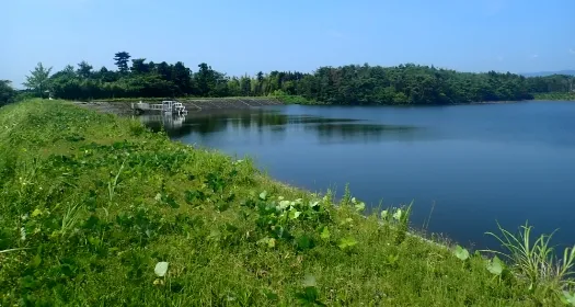
Surveying and design of reservoirs
Reservoirs are important social infrastructure for securing water for agricultural use. We utilize the latest technologies such as UAVs and 3D point clouds to survey and design reservoirs and other facilities.
-
Response to cliff collapses
Even in the event of a landslide, we can safely confirm the situation immediately after the disaster by acquiring 3D point cloud data using UAVs, etc., and move on to swift removal of the debris. Drawings can be created from the point cloud data, and an accurate restoration plan can be drawn up.
-
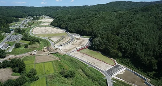
Tanoiri Industrial Park
In addition to developing the housing complex and residential land, we also carried out a series of designs for related roads, drainage, retention ponds, parks, and water supply and sewerage plans.
-
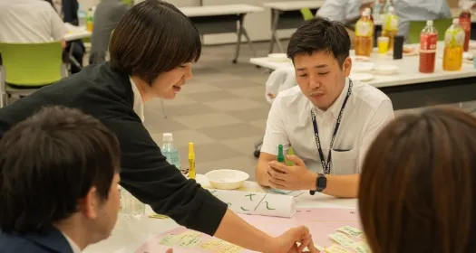
Support for resident-led urban development
We are supporting resident-led urban development in Tomioka Town, Naraha Town, Minamisoma City's Odaka Ward, etc. We hold workshops to discuss future concepts and plans for each region together with residents, local businesses, and the government.
-
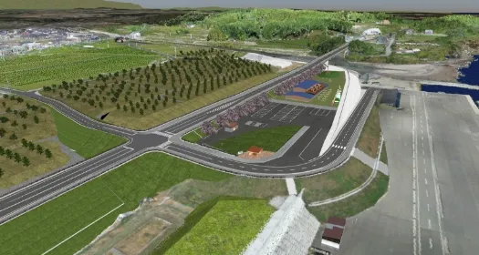
Creating a vision of the future using VR
We are creating future images using VR to support planning studies. By reflecting the opinions of stakeholders in the VR, comparing the appearance (landscape) over time, and conducting traffic simulations, we aim to reach a smooth consensus with all parties involved.
-
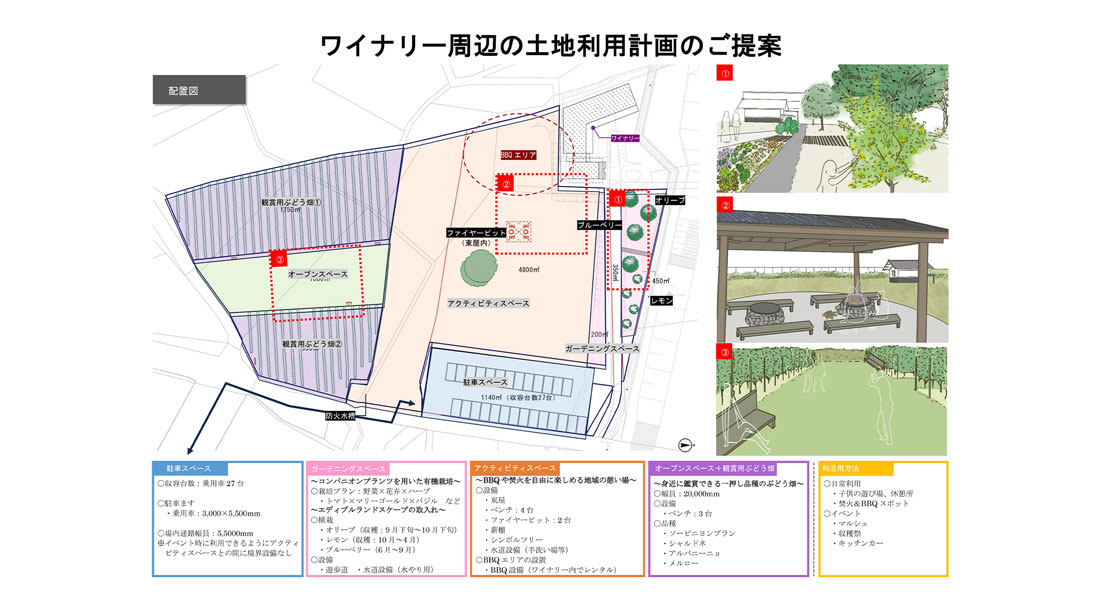
Regional branding support
We are supporting branding efforts that utilize local resources to further restore and revitalize the region. To date, we have considered land use plans for the wine garden, with the aim of creating a new tourism and exchange hub.
List of work and resultsList of operations and results
| year | Client | Business content |
|---|---|---|
| R04 | Fukushima Prefecture | Tsunami-affected area drainage plan development contract |
| R04 | Fukushima Prefecture | Contract for the formulation of longevity plans (rivers and grants) |
| R04 | Fukushima Prefecture | Surveying and design work outsourcing (fishing port disaster investigation) |
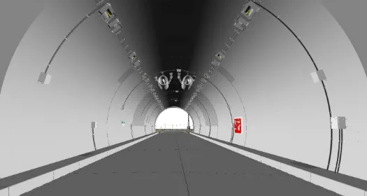
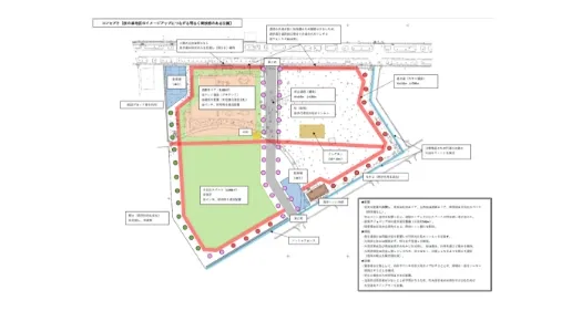
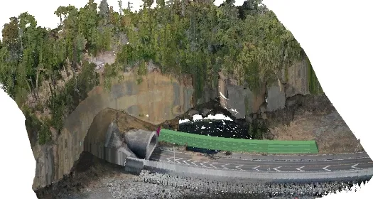
| R04 | Fukushima Prefecture | Fukushima Robot Test Field Test Tunnel 3D Model Creation Contract |
| R04 | subcontractor | FY2022 "Decarbonization x Reconstruction Urban Development" FS commissioned work |
| R04 | Fukushima Prefecture | Bridge inspection work outsourcing (Road Maintenance/Subsidy) |
| R04 | City/town/village | Forest comprehensive maintenance design work outsourcing |
| R04 | Fukushima Prefecture | Contract for the formulation of longevity plans (rivers and grants) |
| R04 | City/town/village | Disaster investigation, surveying, and design work outsourcing |
| R04 | Fukushima Prefecture | Agriculture, Forestry and Fisheries 0301 Business Design |
| R04 | Fukushima Prefecture | 3D model creation project for Fukushima Robot Test Field test bridge |
| R03 | Fukushima Prefecture | Survey design work outsourcing (road preparation/restoration) |
| R03 | Fukushima Prefecture | Surveying and design work outsourcing (urban parks and memorials) |
| R03 | City/town/village | Pipeline restoration survey and design commission |
| R03 | City/town/village | Survey and design work for three routes outside the elementary school line |
| R03 | City/town/village | Hydrographic survey design work outsourcing |
| R03 | City/town/village | Forest Comprehensive Development Project Survey and Design Outsourcing |
| R03 | City/town/village | Sewerage pipeline facility disaster recovery survey and design outsourcing |
| R03 | private company | Extending the life of the General Athletic Park |
| R03 | private company | Commissioned work to study the effective promotion of Fukushima Regeneration and Future-Oriented Projects |
| R02 | Fukushima Prefecture | Disaster prevention forest creation (reconstruction and revitalization) 0101 work |
| R02 | Fukushima Prefecture | Surveying and design work outsourcing (urban parks and memorials) |
| R02 | Fukushima Prefecture | Agriculture, Forestry and Fisheries 0201 Business Design |
| R02 | Fukushima Prefecture | Surveying work outsourcing (erosion control facilities) |
| R02 | City/town/village | Outsourcing of route surveying and design work |
| R02 | City/town/village | Sewerage pipeline facility disaster recovery survey and design outsourcing |
| R02 | City/town/village | Water facility repair work surveying and design work outsourcing |
| H31 | Fukushima Prefecture | Bridge inspection work outsourcing (Road Improvement Agency/Issuance) |
| H31 | Fukushima Prefecture | Agriculture, Forestry and Fisheries 0101 Business Design |
| H31 | City/town/village | Site preparation design commission |
| H31 | City/town/village | Forest road disaster recovery survey and design work outsourcing |
| H31 | City/town/village | Survey and design work for disaster recovery of farmland |
| H31 | City/town/village | Survey and design work outsourcing for infrastructure development, etc. |
| H30 | Fukushima Prefecture | Disaster prevention survey and design work |
| H30 | Fukushima Prefecture | Disaster prevention survey and design work |
| H30 | Fukushima Prefecture | Disaster prevention forest non-legal public property survey work |
| H30 | Fukushima Prefecture | Prefectural road survey and design work |
| H30 | Fukushima Prefecture | Drainage channel surveying and design work |
| H30 | City/town/village | Surveying and design work for comprehensive forest development projects |
| H30 | City/town/village | Design work for reservoir water intake facilities, etc. |
| H30 | City/town/village | Town road survey and design work |
| H30 | City/town/village | Facility site development surveying and design work |
| H30 | City/town/village | Surveying and design work for flower bed maintenance at elementary and junior high schools |
| H30 | City/town/village | Drainage channel repair survey and design work |
| H30 | City/town/village | Town road correction design work |