Spatial information consultingGeospatial information
DXの推進とリモートセンシング技術の活用により
復興・創生を促進
UAVや3Dレーザ等によるリモートセンシング技術を中心に機械学習・AI(人工知能)などの最新技術を活用し、様々な情報を見える化することで復興・創生に貢献いたします
●UAV measurement and investigation
●3D laser scanner measurement and investigation
Remote Sensing
●Inspection
Cultural property survey
●Smart Agriculture
●3D Archive
●GIS Construction
●農産物調査、解析
● Machine learning and AI (artificial intelligence)
詳しくは動画をご覧ください
代表的な業務・成果例Typical business / results
-
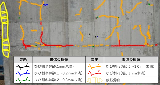
AIによるひびわれ解析
UAVと組み合わせ、手が届かない箇所でも特殊車両を用いず、ひび割れ幅等の損傷状況を確認、評価できます。撮影した画像を合成し成果として作成するため、橋梁全体の点検結果を正確に記録できます。
-
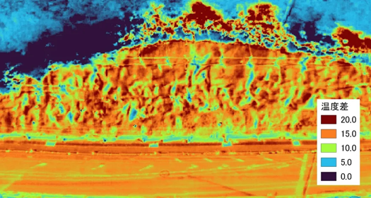
UAVを用いたモルタル吹付法面点検
UAVにより撮影した写真から損傷状況を把握するとともに、サーモグラフィ写真によりモルタル吹付法面の空洞化を判断することで、人の立入が困難な現場でも短時間で調査・計測が可能です。
-
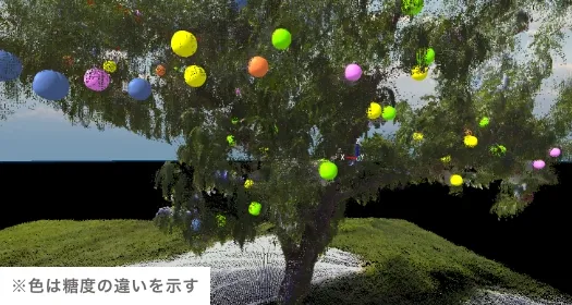
果樹の三次元化
地上レーザ測量を用いて、果樹の三次元点群データを取得することで果実の位置や果樹の状態をデータ化し、果実や剪定の情報も付与することで若手農家への研修やスマート農業の基礎資料として活用できます。
-
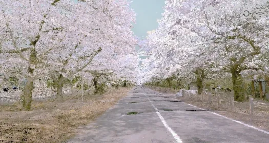
MMSを用いた道路調査
車載写真レーザ測量により、道路および周辺の構造物や植生を三次元点群として取得し、クラック、わだち、支障木などの状況調査を行います。定期的に計測することで経年変化も確認できます。
-
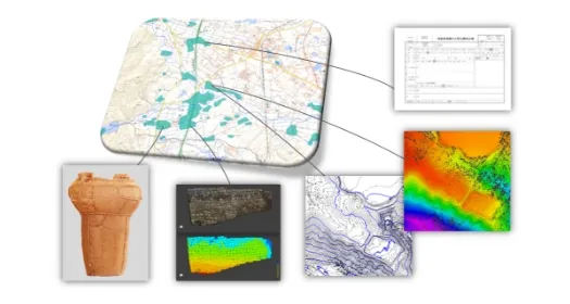
文化財保存・活用の提案
文化財の計測・記録だけでなく、活用のための提案を行っております。GIS、VRをはじめ、 3D動画作成、区域の文化財を管理するための資料整理や台帳作成にも取り組んでいます。
-
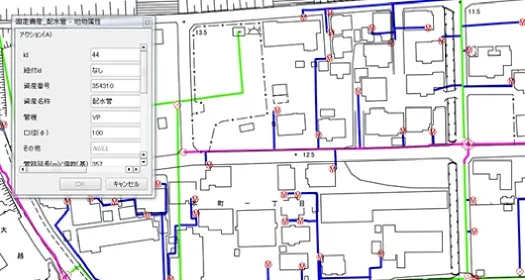
水道GIS
紙やPDFで扱っていた水道台帳をデジタル化して、一枚の地図に水道台帳の情報を付与しました。
-
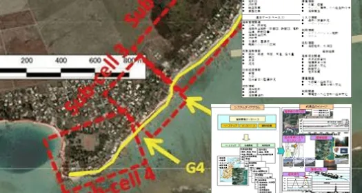
モーリシャス国 海岸GIS + 海岸環境データベースについて最終的な成果イメージ
基礎調査により得られた浸食被害の状況、サンゴ礁生態の状況、過去・現在の被害及び将来的なリスクの状況、海浜の利用、護岸等の海岸保全施設、資産や人口、社会資本の整備状況などの社会経済条件、海象及び地形等の自然条件に関する情報と解析結果を整理し、データベース化を行っています。
業務・成果一覧List of operations and results
| 年度 | 発注者 | 事業内容 |
|---|---|---|
| R04 | 市町村 | 国指定文化遺産(神社)三次元レーザ測量業務委託 |
| R04 | 市町村 | 埋蔵文化財包蔵地台帳更新及びデジタル版遺跡地図作成業務委託 |
| R04 | 市町村 | 県指定文化遺産(建造物)三次元レーザ測量及び文化財保存電子ファイル作成業務 |
| R04 | 大学 | 果樹園レーザー測量_その12業務 |
| R04 | 市町村 | 施設敷地測量調査業務委託 |
| R04 | 民間企業 | 浜通り地域におけるドローンを活用した魅力ある地域づくり調査事業に係るドローンによる実測業務 |
| R03 | 大学 | 果樹園レーザー測量_その7業務 |
| R03 | 市町村 | 震災被災地域等レーザ測量業務 |
| R03 | 国営研究機関 | 毎木レベル森林情報計測及び機械学習手法を用いた樹木情報推定業務 |
| R03 | 国営研究機関 | 労働力不足の解消に向けたスマート農業実証 |
| R03 | 国営研究機関 | ドローンによる冬季森林情報の取得解析業務 |
| R03 | 福島県 | 測量調査業務委託 |
| R03 | 福島県 | 測量業務委託(河海維持) |
| R03 | 市町村 | 震災被災地域等レーザー測量業務 |
| R03 | 市町村 | 正直古墳群地形測量図作成業務 |
| R03 | 民間企業 | 敷地南側法面復旧工事 |
| R03 | 民間企業 | 施設区域の3D画像表示システムの更新業務 |
| R03 | 大学 | 果樹園レーザスキャニング測量 |
| R02 | 大学 | 果樹園地上レーザスキャニング業務 |
| R02 | 研究機関 | ドローンによる冬季森林情報の取得解析業務 |
| R02 | 市町村 | 震災被災地域等レーザー測量業務 |
| H31 | 大学 | 荒川流域付近における斜面崩壊状況地での植生復興過程の把握業務委託 |
| H31 | 大学 | 果樹園地上レーザスキャニング業務 |
| H31 | 研究機関 | 機械学習を用いた森林三次元点群データ解析業務 |
| H31 | 研究機関 | ドローンによる地上線量計測及び地形計測業務 |
| H31 | 民間 | 全体実施設計笹ヶ峰二期地区 Mブロック地すべり機構解析業務 |
| H31 | 市町村 | 震災被災地レーザー測量業務 |
| H31 | 民間 | 南会津におけるUAVレーザー計測 |
| H31 | 民間 | 広瀬大橋UAVレーザー計測 |
| H30 | 福島県 | 文化財UAV写真測量業務 |
| H30 | 市町村 | 工事現場UAV定期空撮業務 |
| H30 | 市町村 | 農地等現状調査結果GIS構築業務 |
| H30 | 市町村 | 桜並木UAV空撮業務 |
| H30 | 市町村 | アーカイブ施設地上レーザスキャニング業務 |
| H30 | 市町村 | 文化財地上レーザ測量業務 |
| H30 | 大学 | 熱赤外カメラUAV空撮画像によるシカ個体数推定手法開発業務 |
| H30 | 大学 | 熱赤外カメラUAV空撮画像による土石流・流域内の斜面崩壊に対する動的情報の技術開発業務 |
| H30 | 大学 | 果樹園地上レーザスキャニング業務 |
| H30 | 大学 | マルチスペクトル・熱赤外カメラによる森林UAV撮影業務 |
| H30 | 民間企業 | 文化財地上レーザスキャニング業務 |