Spatial information consultingGeospatial information
By promoting digital transformation and utilizing remote sensing technology
Promoting reconstruction and revitalization
We will contribute to reconstruction and revitalization by utilizing the latest technologies such as machine learning and AI (artificial intelligence) and remote sensing technology, mainly using UAVs and 3D lasers, to visualize various information.
Please watch the video for details
Representative work and resultsTypical business / results
-
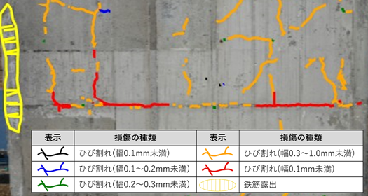
AI-based crack analysis
By combining it with a UAV, it is possible to check and evaluate damage conditions such as crack width even in hard-to-reach areas without using special vehicles. The images taken are synthesized to create the results, allowing for accurate recording of the inspection results for the entire bridge.
-
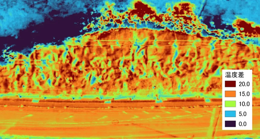
Inspection of mortar sprayed slopes using UAVs
By understanding the extent of damage from photographs taken by the UAV and determining hollows in the mortar sprayed slope using thermography photographs, it is possible to quickly survey and measure even in areas where it is difficult for people to enter.
-
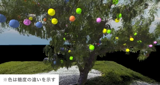
Three-dimensional fruit trees
By using terrestrial laser surveying to obtain three-dimensional point cloud data of fruit trees, the location of the fruit and the condition of the fruit trees can be digitized, and by adding information about the fruit and pruning, the data can be used for training young farmers and as basic information for smart agriculture.
-
Road survey using MMS
Using vehicle-mounted photo laser surveying, roads and surrounding structures and vegetation are captured as 3D point clouds, and conditions such as cracks, ruts, obstructing trees, etc. can be investigated. Periodic measurements can also be used to check for changes over time.
-
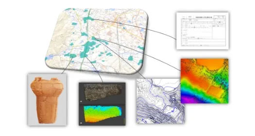
Proposals for preserving and utilizing cultural assets
We not only measure and record cultural properties, but also offer suggestions for their utilization. We also use GIS, VR, 3D video production, and document organization and ledger creation to manage the cultural properties of the area.
-
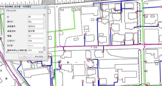
Waterworks GIS
The water supply ledger, which was previously handled on paper or in PDF format, was digitized and the information was added to a single map.
-
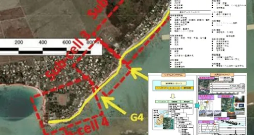
Mauritius Coastal GIS + Coastal Environmental Database Final Product Image
We are organizing and creating a database of information and analysis results obtained through basic surveys on the status of erosion damage, the status of coral reef ecology, past and present damage and future risks, socio-economic conditions such as beach use, coastal protection facilities such as revetments, assets, population, and the status of social capital development, as well as natural conditions such as oceanographic and topographical conditions.
List of work and resultsList of operations and results
| year | Client | Business content |
|---|---|---|
| R04 | City/town/village | Nationally designated cultural heritage (shrine) 3D laser surveying outsourcing |
| R04 | City/town/village | Update of buried cultural property land register and outsourcing of digital archaeological site map creation |
| R04 | City/town/village | Prefectural cultural heritage (buildings) 3D laser surveying and cultural property preservation electronic file creation |
| R04 | university | Orchard laser surveying_12th task |
| R04 | City/town/village | Facility site surveying and investigation outsourcing |
| R04 | private company | Drone survey work for the Hamadori region's attractive community development research project |
| R03 | university | Orchard laser surveying_7th business |
| R03 | City/town/village | Laser surveying of earthquake-affected areas |
| R03 | National Research Institute | Measurement of forest information at the tree level and estimation of tree information using machine learning techniques |
| R03 | National Research Institute | Demonstration of smart agriculture to resolve labor shortages |
| R03 | National Research Institute | Collection and analysis of winter forest information using drones |
| R03 | Fukushima Prefecture | Surveying and investigation outsourcing |
| R03 | Fukushima Prefecture | Surveying work outsourcing (river and sea maintenance) |
| R03 | City/town/village | Laser surveying of earthquake-affected areas |
| R03 | City/town/village | Masanao Kofun Group Topographical Survey Map Creation |
| R03 | private company | Restoration work on the south side slope of the site |
| R03 | private company | Updating the 3D image display system for facility areas |
| R03 | university | Orchard laser scanning survey |
| R02 | university | Orchard ground laser scanning work |
| R02 | Research Institute | Collection and analysis of winter forest information using drones |
| R02 | City/town/village | Laser surveying of earthquake-affected areas |
| H31 | university | Contract to understand the process of vegetation restoration in areas affected by slope collapses near the Arakawa River basin |
| H31 | university | Orchard ground laser scanning work |
| H31 | Research Institute | Forest 3D point cloud data analysis using machine learning |
| H31 | Research Institute | Ground dose measurement and topographical measurement using drones |
| H31 | private | Overall implementation design Sasaga Mine Phase 2 District M Block landslide mechanism analysis work |
| H31 | City/town/village | Laser surveying of earthquake-stricken areas |
| H31 | private | UAV laser measurement in Minamiaizu |
| H31 | private | UAV laser measurement of Hirose Bridge |
| H30 | Fukushima Prefecture | Cultural property UAV photogrammetry service |
| H30 | City/town/village | Regular UAV aerial photography of construction sites |
| H30 | City/town/village | Survey results of current state of farmland, etc. GIS construction work |
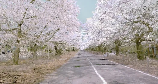
| H30 | City/town/village | Cherry blossom tree UAV aerial photography |
| H30 | City/town/village | Archive facility terrestrial laser scanning work |
| H30 | City/town/village | Cultural property terrestrial laser surveying |
| H30 | university | Development of a method for estimating deer populations using thermal infrared camera UAV aerial images |
| H30 | university | Technical development work for dynamic information on debris flows and slope failures in river basins using thermal infrared camera UAV aerial images |
| H30 | university | Orchard ground laser scanning work |
| H30 | university | Forest UAV photography using multispectral and thermal infrared cameras |
| H30 | private company | Cultural property terrestrial laser scanning business |